A JFK Airport Map helps travelers navigate one of the busiest airports in the United States. Officially known as John F. Kennedy International Airport, JFK Airport serves millions of domestic and international passengers every year. Whether you’re looking for a JFK Airport terminal map, parking map, AirTrain map, or a printable JFK Airport map PDF, having a clear airport layout can make your journey smoother and more efficient.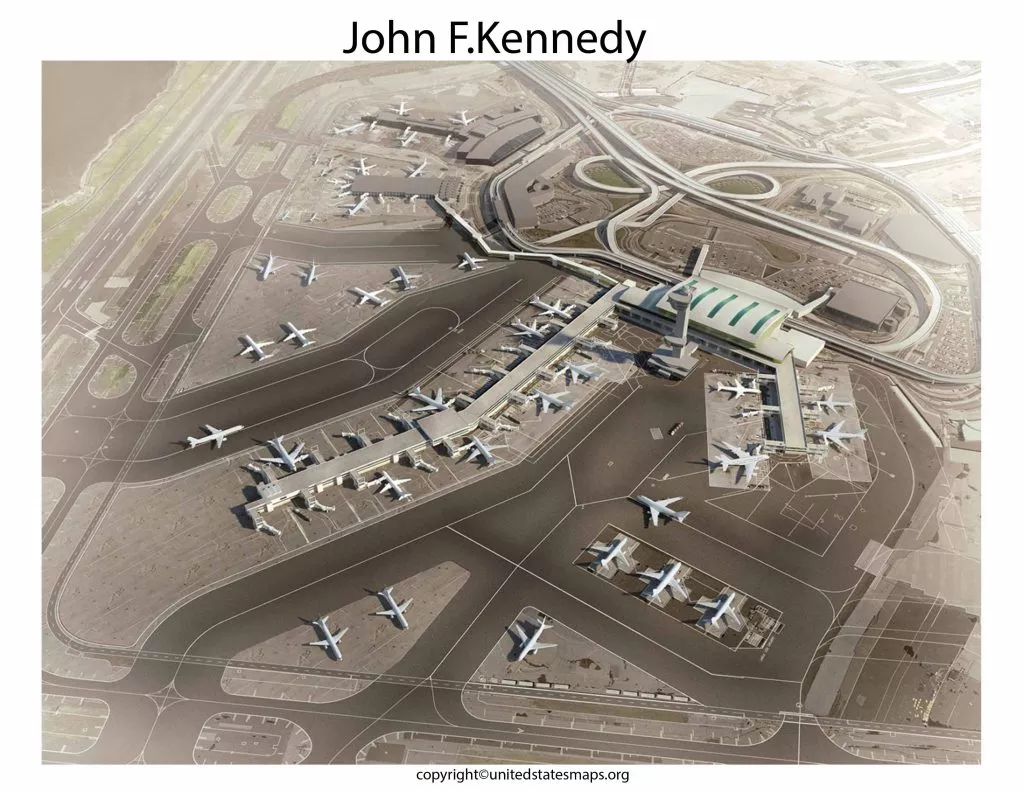
JFK Airport Terminal Map
JFK Airport consists of multiple passenger terminals connected by the AirTrain system. Each terminal serves different airlines and destinations.
| Terminal | Major Airlines |
|---|---|
| Terminal 1 | International Airlines |
| Terminal 4 | Delta Air Lines and International Carriers |
| Terminal 5 | JetBlue Airways |
| Terminal 7 | International Airlines |
| Terminal 8 | American Airlines |
A JFK Airport terminal map helps travelers locate airline check-in counters, security checkpoints, gates, baggage claim areas, and terminal services before arriving at the airport.
JFK Airport Gate Map
A JFK Airport gate map is useful for finding departure and arrival gates quickly. Large international terminals can have multiple concourses and gate areas, making navigation challenging for first-time visitors.
Using a gate map can help passengers:
- Locate departure gates
- Find connecting flight gates
- Navigate terminal concourses
- Identify nearby dining and shopping areas
- Reach boarding areas more efficiently
Many travelers search for a JFK Airport departure map or JFK Airport arrival map before traveling to avoid confusion inside the terminal.
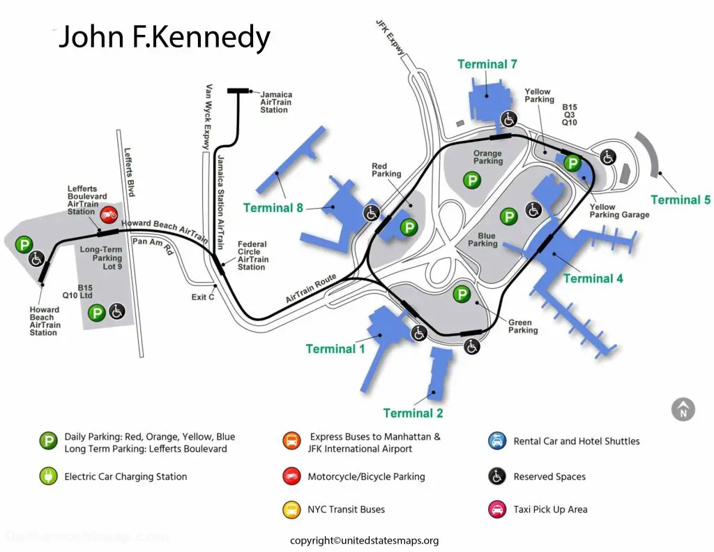
JFK Airport Parking Map
A JFK Airport parking map helps visitors identify available parking areas and choose the best option based on their travel plans.
Common parking options include:
- Short-Term Parking
- Long-Term Parking
- Economy Parking
- Accessible Parking
- Cell Phone Waiting Areas
A parking map can help drivers quickly locate parking lots near their departure terminal and understand the airport’s overall layout.
JFK Airport AirTrain Map
The JFK Airport AirTrain Map is one of the most important navigation tools for travelers.
The AirTrain system connects:
- Terminal 1
- Terminal 4
- Terminal 5
- Terminal 7
- Terminal 8
- Airport parking areas
- Rental car facilities
- Jamaica Station
- Howard Beach Station
The AirTrain provides an easy way to travel between terminals without using a vehicle. Travelers with connecting flights often use the AirTrain to move between different parts of the airport.
JFK Airport Transportation Map
A JFK Airport transportation map shows available ground transportation options throughout the airport.
Transportation services include:
- Airport taxis
- Rideshare pickup zones
- Public buses
- Airport shuttles
- Rental car facilities
- AirTrain connections
- Subway and rail connections
Understanding transportation routes before arriving can help passengers save time and choose the most convenient travel option.
JFK Airport Location Map
JFK Airport is located in the Queens borough of New York City and serves as one of the primary international gateways to the United States.
A JFK Airport location map helps travelers understand the airport’s position relative to:
- Manhattan
- Brooklyn
- Queens
- Long Island
- Major highways and transportation routes
Location maps are especially useful for visitors planning ground transportation and airport transfers.
JFK Terminal Maps
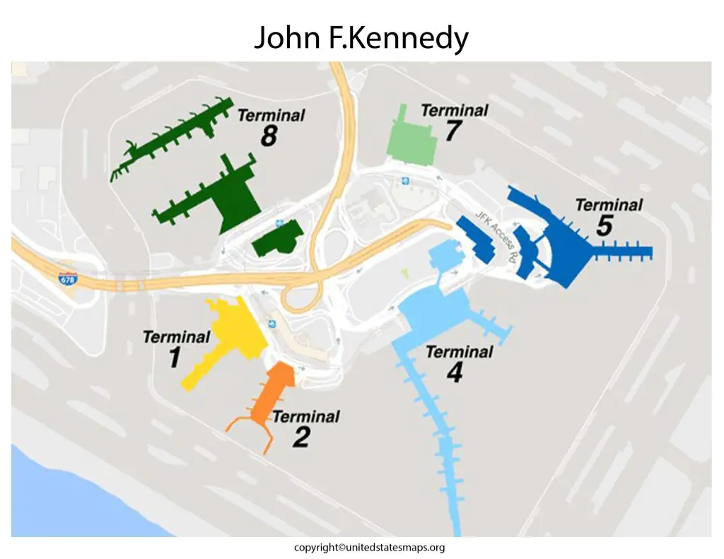
JFK Terminal 1 Map
Terminal 1 primarily serves international airlines and long-haul international flights. A JFK Terminal 1 Map helps travelers locate check-in areas, security checkpoints, gates, lounges, and baggage claim facilities.
JFK Terminal 4 Map
Terminal 4 is one of the busiest terminals at JFK Airport. A JFK Terminal 4 Map is useful for locating departure gates, arrival areas, airline counters, dining options, and terminal services.
JFK Terminal 5 Map
Terminal 5 serves JetBlue Airways and features a modern layout designed to simplify passenger navigation. A JFK Terminal 5 Map helps travelers locate gates, security checkpoints, and terminal amenities.
JFK Terminal 7 Map
A JFK Terminal 7 Map provides information about gates, airline facilities, and passenger services available within the terminal.
JFK Terminal 8 Map
Terminal 8 serves American Airlines and several international carriers. A JFK Terminal 8 Map helps travelers navigate check-in areas, departure gates, baggage claim sections, and airport services.
Printable JFK Airport Map PDF
A Printable JFK Airport Map PDF is useful for travelers who want offline access to airport information before arriving at JFK.
Printable maps can help users:
- Plan terminal navigation
- Locate gates and services
- Identify parking areas
- Review AirTrain routes
- Understand airport transportation options
Many travelers prefer downloading a JFK Airport PDF Map before their trip to make airport navigation easier.
Why Use a JFK Airport Map?
A John F. Kennedy Airport Map provides a convenient way to understand the airport layout before traveling.
Benefits include:
- Faster terminal navigation
- Easier gate identification
- Better parking planning
- Improved connection management
- Simplified airport transfers
- More efficient travel experience
Whether you’re arriving, departing, or connecting through JFK Airport, a detailed airport map can help reduce stress and improve your overall travel experience.
Frequently Asked Questions JFK Airport
How many terminals does JFK Airport have?
JFK Airport currently operates multiple passenger terminals, including Terminals 1, 4, 5, 7, and 8.
What terminal is Delta at JFK?
Delta primarily operates from Terminal 4.
What terminal is JetBlue at JFK?
JetBlue primarily operates from Terminal 5.
How do I get between terminals at JFK?
Passengers can use the AirTrain system to travel between terminals.
Is the JFK AirTrain free?
The AirTrain is generally free for travel between airport terminals.
Where is long-term parking at JFK Airport?
Long-term parking facilities are available within designated airport parking areas and can be located using a JFK Airport parking map.
Can I walk between terminals at JFK?
Some terminal connections may require the AirTrain system, depending on the terminals involved.