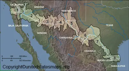
The US Mexico Border Map is one of the longest North American international borders at some 1,954 miles (3,145 km). It runs through deserts, rivers, mountains, and cities and divides the southern United States from northern Mexico.
The US Mexico border is 1,933 miles long, running through four U.S. states and six Mexican states, and facilitating millions of legal crossings annually, while connecting hundreds of communities across the border.
People often look for the latest US-Mexico Border Map to find out what the routes are at the current time, what cities are near the border, and what the main crossing points are. It is also helpful to have a detailed map of the southern border of the United States and the areas served by highways, railways, and international bridges.
Border Highlights
- Border Length: 1,954 miles (3,145 km)
- Starts: Pacific Ocean (California)
- Ends: Gulf of Mexico (Texas)
- International Boundary: United States – Mexico
- Major Natural Border: Rio Grande (Rio Bravo)
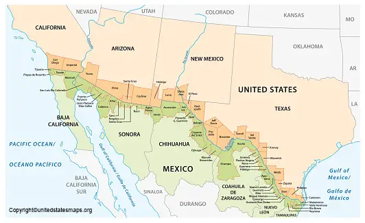
US States That Border Mexico
Only four U.S. states share a border with Mexico.
| US State | Mexican State(s) |
| California | Baja California |
| Arizona | Sonora |
| New Mexico | Sonora & Chihuahua |
| Texas | Chihuahua, Coahuila, Nuevo León & Tamaulipas |
These states are significant in the fields of trade, tourism, transportation, and international commerce. They contain some of the traffic-heavy US-Mexico Border Crossing Locations and the foremost ports of entry.
Mexican States Along the US-Mexico Border Map
On the Mexican side, six states share the international boundary with the United States.
| Mexican State | Borders |
| Baja California | California |
| Sonora | Arizona & New Mexico |
| Chihuahua | New Mexico & Texas |
| Coahuila | Texas |
| Nuevo León | Texas |
| Tamaulipas | Texas |
These two areas combined are one of the most heavily traveled North American cross-border corridors.
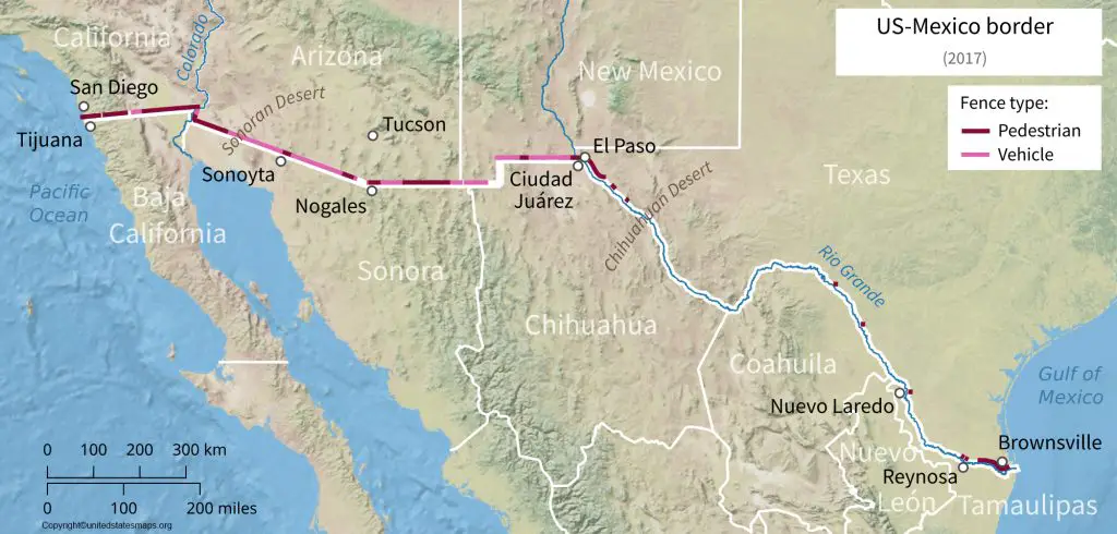
This map displays the major cities and border crossings along the United States-Mexico border. This map shows the major cities and border crossings on the U.S.-Mexico border.
US-Mexico Border Map with Cities
A common search query for a map is a US-Mexico Border Map with Cities, which is used to locate key metros along the border. Highways, bridges, ports of entry, and commercial trade routes link these cities together.
Some of the most important US-Mexico Border Cities include:
| United States | Mexico |
| San Diego | Tijuana |
| El Paso | Ciudad Juárez |
| Nogales | Nogales |
| Laredo | Nuevo Laredo |
| Brownsville | Matamoros |
| McAllen | Reynosa |
| Eagle Pass | Piedras Negras |
These cities are among the busiest areas for international commerce, travel, and commuting. A US-Mexico Border Map with Cities is used by many travelers to plan road trips, find nearby border crossings, and learn about the geography of the region.
US Mexico Border Map Crossing Locations
US Mexico Border Crossing Locations are the official entry points for people, vehicles, and cargo to move across the U.S.-Mexico border. The crossings are under customs and immigration control and are important for international trade and tourism.
Some of the busiest border crossings include:
- San Ysidro Port of Entry (California – Tijuana) – One of the busiest land border crossings in the world.
- El Paso – Ciudad Juárez – A major commercial and passenger crossing.
- Nogales Port of Entry (Arizona – Sonora) – Important for trade and freight movement.
- Laredo – Nuevo Laredo – The busiest commercial trade corridor between the U.S. and Mexico.
- Brownsville – Matamoros – Popular for regional travel and commerce.
- Eagle Pass – Piedras Negras – A key crossing for both passenger and freight traffic.
A comprehensive US-Mexico Border Crossing Map helps travelers find ports of entry, local highways, bridges, and inspection facilities.
US-Mexico Border Wall Map
The US Mexico Border Wall Map is a map that is sought by many people to find out where the border barriers are located along the U.S-Mexico Border. The border is almost 1,954 miles (3,145 km) long, but there are only a few areas where there is a physical barrier. The barriers differ in design and are mostly located near high-traffic-volume urban areas and key border crossings.
The US–Mexico border wall will be used to assist in border security and to control illegal crossings, but significant stretches of the border are still open and are marked by natural barriers like rivers, mountains, and desert terrain. A detailed border wall map assists users in determining where barriers are and how they are connected to neighbouring cities and official ports of entry.
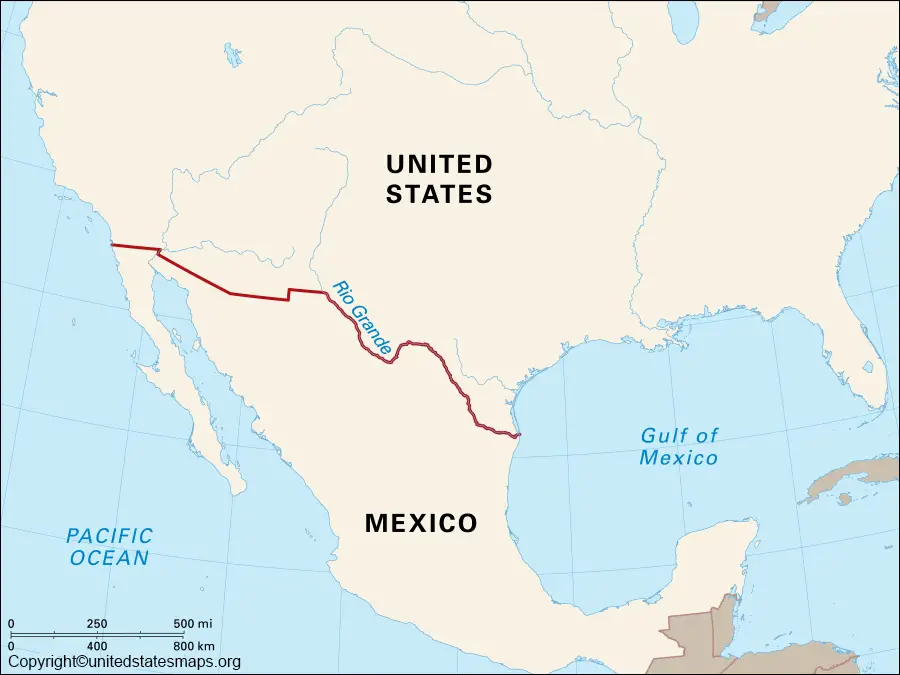
Rivers Along the US Mexico Border Map
A US-Mexico Border Map has the Rio Grande, also referred to as the Río Bravo del Norte in Mexico, as one of the most important natural features. The river is a major border with Mexico, particularly with the Mexican states of Chihuahua, Coahuila, Nuevo León, and Tamaulipas, and Texas.
The Colorado River also forms a small part of the border between California, Arizona, and Baja California in the west.
The rivers have been significant in defining the border, providing habitat for wildlife and the support of agriculture, and in water resource management in the region.
Printable US-Mexico Border Map PDF
Printable US-Mexico Border Map PDF can be helpful for those who are looking for an educational, travel or research map of the border between the United States and Mexico. The downloadable version enables users to display the state and city boundaries, rivers, highways, and crossing points without an internet connection.
Common uses include:
- Classroom and geography lessons
- School and college projects
- Travel planning
- Logistics and transportation
- Border region research
- Business presentations
Printable US-Mexico Border Map PDF
Why Use This US-Mexico Border Map?
This map is intended to assist users in gaining a rapid overview of the geography and layout of the international boundary.
It can be used to:
- Locate US-Mexico Border Cities
- Find US-Mexico Border Crossing Locations
- Identify the four U.S. border states
- View the six Mexican border states
- Understand the US-Mexico Border Length
- Study the Rio Grande and other natural boundaries
- Plan cross-border travel routes
- Support educational and research projects
- Download a Printable US-Mexico Border Map
A student, teacher, traveller, or researcher can easily and reliably get a quick overview of one of the busiest international borders in the world.
Related Maps
If you’re exploring the US-Mexico Border Map, you may also find these maps useful:
Maps that are related to this map are also available, and these can be used to go into other areas in greater detail.
Frequently Asked Questions (FAQs)
How long is the US Mexico border?
The U.S.-Mexico border stretches from the Pacific Ocean in the West to the Gulf of Mexico in the East, and is about 1,954 miles (3,145 kilometers) in length.
Which US states border Mexico?
California, Arizona, New Mexico, and Texas are the four U.S. states that border Mexico.
Which Mexican states border the United States?
The six Mexican states are Baja California, Sonora, Chihuahua, Coahuila, Nuevo León, and Tamaulipas.
What are the major US-Mexico border cities?
The major border cities include San Diego-Tijuana, El Paso-Ciudad Juárez, Nogales, Laredo-Nuevo Laredo, Brownsville-Matamoros, and McAllen-Reynosa.
What is the busiest US-Mexico border crossing?
San Ysidro Port of Entry (PoE) between San Diego and Tijuana is well known as one of the busiest land ports in the world.
Can I download a printable US-Mexico Border Map PDF?
Yes. Printable PDF is perfect for classes, studies, travel planning, or reference in the absence of a computer.
Does the entire US-Mexico border have a wall?
No, there are some physical barriers in certain parts of the border, and lots of areas are formed by rivers, mountains, and deserts.
Which river forms the US Mexico border?
Most of the boundary between Texas and northern Mexico is the Rio Grande (Río Bravo del Norte).
What are the US-Mexico Border Crossing Locations?
They are official points of crossing between the United States and Mexico for vehicles and travelers.
Why should I use a US-Mexico Border Map?
The detailed map is useful for education, travel, and research as it can help identify border states, cities, rivers, ports of entry, and major routes of transportation.
Conclusion
The US-Mexico Border Map is an important tool for understanding the international boundary between the United States and Mexico. It shows border states, big cities, rivers, official crossing points, and selected parts of the wall, as well as giving an overview of one of North America’s most significant geographic areas. This guide is a useful and convenient reference for students, travelers, teachers, and researchers for the US-Mexico Border Map with Cities, Printable US-Mexico Border Map PDF, and US-Mexico Border Crossing Locations.