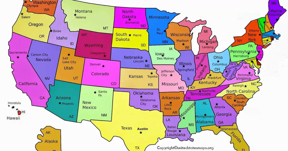
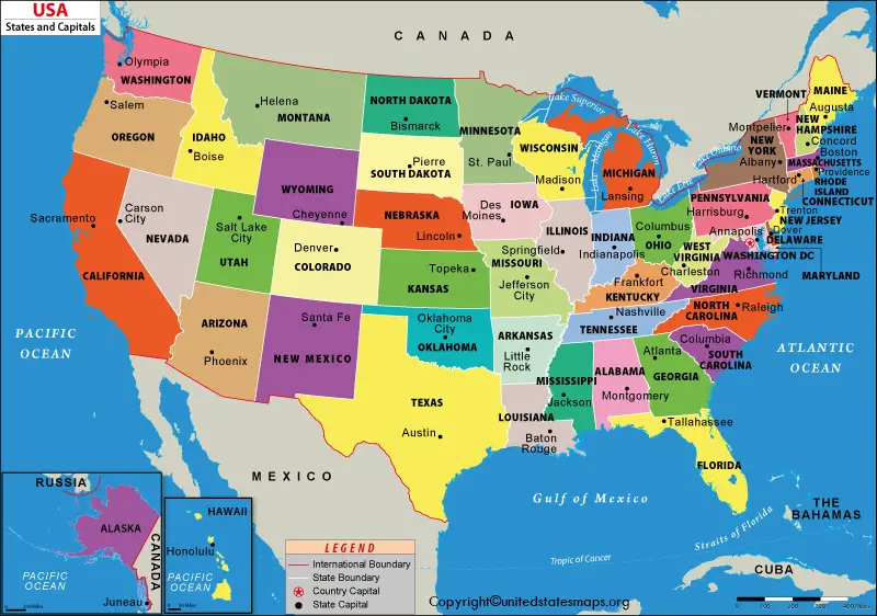
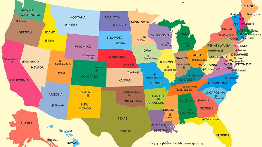
A US Map with Capitals is one of the most useful Geography resources for students, teachers, travelers, and anybody interested in learning about the United States. It displays all U.S. states and their capitals, simplifying the understanding of the political divisions and states in the United States of America.
A United States map with capitals can be used for a variety of purposes, such as studying geography, planning a road trip, using it for a classroom lesson, or even to simply explore the United States. This is not a map of the state, but one that is more in-depth, and it will show the administrative centers at which each state government is based.
We have designed our USA map with capitals to be simple, accurate, and easy to read. It can be used for school projects or educational purposes, for homeschooling, for travelling, or as a reference. Download the high-resolution US map with capitals for offline use if you need to print it.
Printable US Map with Capitals
A printable USA map with capitals is perfect for classroom and office applications. You are not required to browse several maps to find one with all states and their capitals clearly marked; you can download a map that does that.
This map can be used for:
- Learning all 50 state capitals
- Geography homework and classroom activities
- Homeschool lessons
- Travel and route planning
- Government or administrative reference
- Quiz preparation
- Office presentations
A lot of users also like a labelled, outlined map of the USA with capitals, as it will make it easier for them to identify the states and the capital cities. A blank US map with capitals would also be a great geography practice tool to test your knowledge.
What Does a US Map with Capitals Show?
A US States and capitals map is much more than just state boundaries. It provides important geographic and political information in a single view.
A standard map typically includes:
- All 50 U.S. states
- Every official state capital
- Clearly marked state boundaries
- State names
- Capital city locations
- National capital (Washington, D.C.)
- Major geographic regions
- Easy-to-read labels
Some versions may also include major cities, highways, rivers, or surrounding countries, which can help with travel and research.
Download Free US Map with Capitals
When it comes to finding a free printable US map with capitals PDF, it’s important to select the best version. A map that is easy to read and print, and can be used in classrooms or presentations.
It can be offered in a variety of formats, such as:
- PDF for printing
- PNG for presentations
- JPG for documents
- High-resolution images for posters
- Black-and-white printable versions
- Color political maps
These downloadable versions are particularly helpful for students, teachers, researchers, and those seeking a dependable map of the U.S. that shows the capitals.
Complete List of All 50 States and Their Capitals
The table below shows all of the U.S. states and their official capital cities.
| State | Capital |
| Alabama | Montgomery |
| Alaska | Juneau |
| Arizona | Phoenix |
| Arkansas | Little Rock |
| California | Sacramento |
| Colorado | Denver |
| Connecticut | Hartford |
| Delaware | Dover |
| Florida | Tallahassee |
| Georgia | Atlanta |
| Hawaii | Honolulu |
| Idaho | Boise |
| Illinois | Springfield |
| Indiana | Indianapolis |
| Iowa | Des Moines |
| Kansas | Topeka |
| Kentucky | Frankfort |
| Louisiana | Baton Rouge |
| Maine | Augusta |
| Maryland | Annapolis |
| Massachusetts | Boston |
| Michigan | Lansing |
| Minnesota | Saint Paul |
| Mississippi | Jackson |
| Missouri | Jefferson City |
| Montana | Helena |
| Nebraska | Lincoln |
| Nevada | Carson City |
| New Hampshire | Concord |
| New Jersey | Trenton |
| New Mexico | Santa Fe |
| New York | Albany |
| North Carolina | Raleigh |
| North Dakota | Bismarck |
| Ohio | Columbus |
| Oklahoma | Oklahoma City |
| Oregon | Salem |
| Pennsylvania | Harrisburg |
| Rhode Island | Providence |
| South Carolina | Columbia |
| South Dakota | Pierre |
| Tennessee | Nashville |
| Texas | Austin |
| Utah | Salt Lake City |
| Vermont | Montpelier |
| Virginia | Richmond |
| Washington | Olympia |
| West Virginia | Charleston |
| Wisconsin | Madison |
| Wyoming | Cheyenne |
US Regions and Their State Capitals
The USA can be divided into four distinct geographical regions. The capital cities of the regions, along with their landscapes, climates, and cultures, vary from region to region.
Northeast Region
The Northeast comprises Maine, Vermont, New Hampshire, Massachusetts, Rhode Island, Connecticut, New York, New Jersey, and Pennsylvania. The cities of Boston, Hartford, Albany, and Trenton are important in American history and government.
Midwest Region
States in the Midwest region include Illinois, Indiana, Michigan, Ohio, Wisconsin, Minnesota, Iowa, Missouri, Kansas, Nebraska, North Dakota, and South Dakota. Major administrative centers include the capitals of Springfield, Indianapolis, Lansing, Madison, and Saint Paul.
Why Learn State Capitals?
Knowing the state’s capital helps with geographic knowledge and easier understanding of the organization of the U.S. A USA map with capitals is a useful exercise for students to learn the locations of state government centers, and travelers can employ it to plot their routes and select state government centers.
The capital of each state will also come in handy for competitive exams, educational quizzes, and general knowledge. A USA political map with capitals will help you to remember the capitals.
South and West Regions of the United States
The Southern United States includes Texas, FLORIDA, GEORGIA, ALABAMA, LOUISIANA, Tennessee, Kentucky, Mississippi, Arkansas, South Carolina, Virginia, West Virginia, Oklahoma, and MARYLAND. Austin, Tallahassee, Atlanta, Montgomery, Baton Rouge, Nashville, Frankfort, Jackson, Little Rock, Raleigh, Columbia, Richmond, Charleston, Oklahoma City, and Annapolis are their capitals.
The western United States has a variety of deserts, mountain ranges, and the Pacific coast regions. The states in this region are California, Alaska, Arizona, Colorado, Hawaii, Idaho, Montana, Nevada, New Mexico, Oregon, Utah, Washington, and Wyoming. Politically and administratively important capitals include Juneau, Juneau, Juneau, Phoenix, Denver, Honolulu, Boise, Helena, Carson City, Santa Fe, Salem, Salt Lake City, Olympia, and Cheyenne.
Interesting Facts About US State Capitals
Every state capital has its own history and unique characteristics. Here are a few interesting facts:
- Juneau, Alaska, is one of the few U.S. state capitals that cannot be reached by road. Most visitors arrive by plane or ferry.
- Phoenix, Arizona, is the largest state capital by population.
- Montpelier, Vermont, is the smallest U.S. state capital by population.
- Denver, Colorado, is known as the “Mile High City” because it sits about one mile above sea level.
- Austin, Texas, is famous for its live music, technology industry, and cultural attractions.
- Sacramento, California, became the state’s permanent capital in 1854.
- Boston, Massachusetts, is one of the oldest cities in the United States and played a major role in American history.
These facts make learning geography more interesting and help students remember state capitals more easily.
Washington, D.C. vs. State Capitals
Many people confuse Washington, D.C., with the state of Washington, but they are completely different.
- Washington, D.C., is the capital of the United States. It is a federal district and is not part of any state.
- Every U.S. state has its own state capital, where the governor’s office, state legislature, and other government departments are located.
- For example:
- California → Sacramento
- Texas → Austin
- Florida → Tallahassee
- New York → Albany
Understanding this difference is important for geography students and anyone learning about the U.S. government.
How Can You Use This US Map with Capitals?
The United States map with capitals comes in handy in many scenarios:
- Memorize all the state capitals of the U.S. States in no time.
- Study for tests and quizzes in Geography.
- Help in class and homeschooling.
- Know the location of states and plan road trips.
- Utilize it as a reference for projects and presentations.
- Enhance the overall understanding of U.S. geography.
A map of the United States with the capitals is a handy and dependable map for students, teachers, travelers, or researchers.
Frequently Asked Questions
A map of the United States that shows the capitals.
The map of the USA with capitals depicts the fifty states of the United States, along with their capitals. It aids users in comprehending the political and geographical profile of a country.
Can I print the US map with capitals?
Yes. It is available in printable PDF, PNG, and JPG formats for use in class, for homework, or for personal use.
What is the capital of the United States?
Washington, D.C. (not a state) is the capital of the United States.
How many state capitals are there?
There are 50 state capitals, one for each U.S. state.
Which is the largest state capital?
Arizona’s capital is Phoenix, which is the biggest city.
Which is the smallest state capital?
Montpelier, Vermont, is the least populated state capital in the United States.
Why is learning state capitals important?
Learning the capitals of states aids in the development of geography skills, helps in education and competitive exams in the United States, and improves an understanding of the United States.
Conclusion
A US Map with Capitals is more than merely a geography reference. It’s a good educational resource for students, teachers, travelers, and anyone who wants to know about the U.S. State boundaries and capital cities, which are clearly marked, making it easy and fun to learn about the geography of the country.
This is the perfect resource for finding the capital of each state on a US map, whether you’re looking for a printable map of the United States with the capitals, a labeled map of the United States with capitals, or a handy reference for school or travel. Save this page or download the map to keep handy for quick reference when you need a complete, accurate, 50-state and capitals reference map.