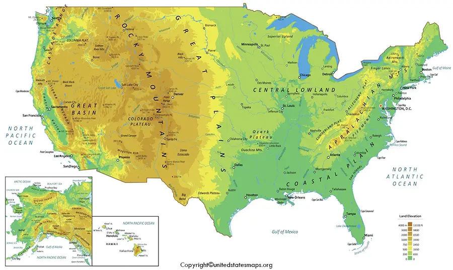
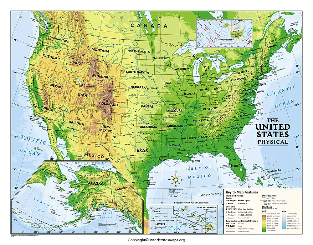
What Is a Geographical Map of USA?
The geographical map of USA displays the geographical features of all the states of the USA, like mountains, rivers, lakes, deserts, plains, and other natural features. A geographical map emphasizes the landforms and terrain that make up the United States, rather than state boundaries and capitals, as is done in a political map.
The United States is one of the largest countries in the world, with an area of almost 3.8 million square miles. This country has an amazing diversity of landscapes, ranging from the majestic Rocky Mountains on the west to the rolling hills of the Appalachian Mountains on the east. A USA geographical map will enable the user to gain an understanding of the distribution of these natural features around the USA.
A United States geographical map can be useful for a variety of purposes, including studying geography, creating classroom maps, and planning trips around the United States. It helps the learner to gain an understanding of the geographical features of the country and how these features affect the climate, transport, farming, and settlement patterns.
Printable Geographical Map of USA With PDF
Printable geographical map of the USA is helpful for school, college, office, and for reference. The maps are of high resolution and can be used in the study of physical geography to identify mountain ranges, locate major rivers, and understand the diverse landscape of a country.
You can use a printable map for:
- Geography assignments
- Classroom presentations
- Homeschool learning
- Travel planning
- Research projects
- General knowledge
- Wall displays
- Educational quizzes
Many also want a high-resolution geographical map of the USA because of the great detail and ease of printing large maps.
Geographical Map of the USA With PDF
Major Physical Features of the United States
The USA is one of the most diversified countries in the world. Geography features high mountains, vast plains, big river systems, deserts, forests, coastlines, and thousands of lakes.
A physical map of the United States should show:
- Major mountain ranges
- Rivers and lakes
- Plains and grasslands
- Plateaus
- Deserts
- Coastal regions
- Forest areas
- Elevation changes
These natural conditions have an impact on weather, wildlife, farming, transportation, and the economy throughout the nation.
Major Mountain Ranges in the USA
One of the most recognizable aspects of any geography map of the USA is the mountains. They span the various regions and establish their own climate and ecology.
Rocky Mountains
The Rocky Mountains range from New Mexico into Canada, through Colorado and Wyoming, and into Montana. They are one of the most significant mountain regions in North America and are a popular destination for camping, hiking, skiing, and observing wildlife.
Appalachian Mountains
Located in the eastern United States, the Appalachian Mountains run from Alabama to Maine. These old mountains are famed for their beauty, forests, and hiking trails, including parts of the renowned Appalachian Trail.
Sierra Nevada
Most of the Sierra Nevada mountain range is in California and Nevada. It contains Mount Whitney, the tallest point in the United States, and is where such well-known National Parks can be found, such as Yosemite National Park.
Cascade Range
The Cascade range is found in Washington, Oregon, and northern California. It has some volcanic mountains such as Mount Rainier, Mount Hood, and Mount St. Helens.
Major Rivers and Lakes
There are thousands of rivers and lakes in the United States that provide transportation, agricultural water, wildlife, and recreational activities.
Mississippi River
The Mississippi River is a great river of North America. It runs from Minnesota to the Gulf of Mexico and is a critical artery for moving goods and farm products.
Missouri River
The longest river in the United States is the Missouri River, which starts in Montana and ends where it meets the Mississippi River near St. Louis, Missouri.
Colorado River
The Colorado River runs through the southwestern United States and is a well-known river for creating the Grand Canyon. Provides water services to millions of people in multiple western states.
Great Lakes
The Great Lakes are the largest surface area of freshwater lakes in the world and are made up of Lakes Superior, Michigan, Huron, Erie, and Ontario. They are important in the transportation, tourism, fishing, and trading sectors.
Plains and Grasslands
The Great Plains are the central part of the United States, from Texas to North Dakota. This is a very broad area, characterized by fertile fields, open grasslands, and large-scale farming. The plains are one of the most productive farming regions in the country, with wheat, corn, and soybeans common crops.
Deserts and Plateaus of the United States
The Geographical Map of the USA also shows the deserts and plateaus of the country, which are mainly located in the western and south-western side of the country. The landscapes are characterized by special rock formations, dry climate, and stunning views.
Great Basin Desert
Nevada and parts of Utah, Oregon, Idaho, and California are part of the Great Basin Desert. It is the biggest desert in the United States and has mountain ranges, salt flats, and large valleys in it.
Mojave Desert
The Mojave Desert is a hot place in California, Nevada, Utah, and Arizona, known for its Joshua Tree. It is one of the most popular areas of North America’s desert.
Sonoran Desert
The Sonoran Desert is an area shared by Arizona and parts of California in the United States, and into Mexico. It is home to the giant saguaro cactus and is home to a variety of desert wildlife.
Colorado Plateau
The Colorado Plateau is a region that encompasses Arizona, Utah, Colorado, and New Mexico. This area features the dramatic canyons, mesas, arches, and national parks such as the Grand Canyon, Arches National Park, and Canyonlands National Park.
Coastal Regions of the USA
There are thousands of miles of coastline in the United States along the Atlantic Ocean, Pacific Ocean, Gulf of Mexico, and Arctic Ocean. Coastal zones affect the weather, sea ecology, tourism, and trade.
Atlantic Coast
The Atlantic Coast runs from Maine to Florida. It features sandy beaches, historical cities, estuaries, and major ports for trade and tourism.
Pacific Coast
The Pacific coast stretches from Washington to California. It’s famous for rugged cliffs, coastal forests, sandy beaches, and scenic highways like the Pacific Coast Highway.
Gulf Coast
Texas, Louisiana, Mississippi, Alabama, and Florida are part of the Gulf Coast. It’s a place where warm beaches, wetlands, seafood businesses, and key seaport facilities are all in good repute.
Arctic Coast
The northern coast of Alaska is on the Arctic Ocean. The area is quite remote with glaciers, tundra, and special wildlife for cold conditions.
Climate Regions of the United States
The country’s diverse geography creates several different climate zones.
- Humid Continental Climate – Common across the Northeast and Midwest, with warm summers and cold winters.
- Humid Subtropical Climate – Found in the Southeast, bringing hot summers and mild winters.
- Desert Climate – Covers parts of Arizona, Nevada, Utah, and California with very low rainfall.
- Mediterranean Climate – Found along coastal California, characterized by dry summers and mild, wet winters.
- Marine West Coast Climate – Seen in Washington and Oregon, where rainfall is common throughout the year.
- Alpine Climate – Present in high mountain regions such as the Rockies and Sierra Nevada.
- Arctic Climate – Found in northern Alaska, with long, extremely cold winters.
Understanding these climate regions helps explain why vegetation, wildlife, and agriculture vary across the United States.
Why Use a Geographical Map of USA?
A USA geographical map is a lot more of a classroom instrument. It enables the learner to appreciate the physical geography of the country and the influence that the physical features have on daily life.
A geographical map should be used for:
- Learning U.S. geography
- Investigating mountain ranges and rivers
- Understanding climate zones
- Organising trips and outdoor activities
- Teaching physical geography
- Research and educational projects
- Preparing for the geography competitions
- Visiting the country park and natural attraction areas
A physical map of the United States is useful for students, teachers, travelers, and researchers because it helps to make complex geographical information easy to understand.
Geographical Map vs. Political Map
Both maps are of the USA, but for different purposes.
| Geographical Map | Political Map |
| Shows mountains, rivers, deserts, lakes, and landforms | Shows states, capitals, cities, and borders |
| Focuses on natural features | Focuses on administrative boundaries |
| Used for geography and environmental studies | Used for government, travel, and administration |
| Displays elevation and terrain | Displays state names and capitals |
When you want to learn about the country’s natural scenery, then you should opt for the Geographical Map of the USA. A political map would be more suitable if you need to locate states, cities, or capitals.
Frequently Asked Questions
What is a Geographical Map of USA?
Geographical Map of the USA: Natural features like mountains, rivers, lakes, deserts, plains, forests, and elevation are shown, not the outline of the states and political boundaries.
What is the difference between a geographical map and a political map?
Geographical maps emphasize natural landforms and terrain, while political maps feature states, capitals, cities, and administrative boundaries.
What are the major mountain ranges in the United States?
The best-known mountain ranges are the Rocky Mountains, the Appalachian Mountains, the Sierra Nevada, the Cascade Range, and the Alaska Range.
What are the major rivers shown on a geographical map?
The key rivers are the Mississippi River, the Missouri River, the Colorado River, the Rio Grande, the Columbia River, and the Ohio River.
What are the five Great Lakes?
The Great Lakes are Lake Superior, Lake Michigan, Lake Huron, Lake Erie, and Lake Ontario. They make up the largest surface area freshwater lake system in the world.
Can I download a printable geographical map of USA?
Yes. Geographical maps that can be printed are provided in PDF, PNG, and JPG formats, for classroom use, a project, a presentation, or for reference.
Why is a geographical map important?
A geographical map aids users in grasping the natural characteristics, climate, ecosystems, and physical geography of the country. It is a must-have in education, travel planning, and environmental studies.
Conclusion
A Geographical Map of USA offers an in-depth look at the country’s natural geography, allowing visitors to discover mountains, rivers, lakes, deserts, plains, plateaus, and the regions of climate. From a geography lesson to a classroom, a trip, or just curiosity, this map is a must-have resource when learning about the various landscapes of the USA.
The geographical map of USA is printable and lets you easily recognize the most important landforms, know the differences between various regions, and appreciate the physical geography of the USA. Print out a large copy for study, travel or research purposes to serve as a trusted guide to the natural features that make the U.S. one of the most geographically diverse countries in the world.