The Colorado Rainfall Map is an invaluable resource for anyone living in or visiting the state. Our comprehensive map provides users with a clear understanding of the average rainfall levels across the state, enabling them to plan their activities accordingly. Whether you’re a skier, a farmer, or just want to stay informed about the weather, our Rainfall Map of Colorado is an essential tool.
Check out our other Rainfall related Maps:
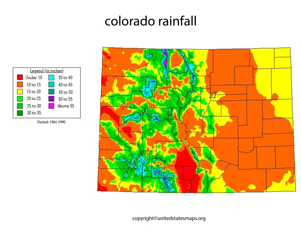
Colorado is a state located in the western region of the United States, known for its beautiful natural landscapes, including mountains, forests, and national parks. One of the essential elements that contribute to the unique environment in Colorado is rainfall. The Colorado rainfall map represents the amount of precipitation that falls in different parts of the state throughout the year.
The rainfall in Colorado varies significantly depending on the location and elevation. The eastern part of Colorado tends to be drier, with an average annual rainfall of around 15 inches. In contrast, the western part, which is mountainous, receives much more precipitation, with an average annual rainfall of around 50 inches. Additionally, the timing and intensity of precipitation also vary across the state, with some regions experiencing heavy rain or snowfall during specific seasons.
To create the Colorado rainfall map, experts use data from various sources, including weather stations, satellite imagery, and radar technology. They analyze this data to create a visual representation of the average rainfall in different regions of the state. This map is helpful for understanding the climate and weather patterns in Colorado and can assist in making informed decisions about water usage and conservation efforts.
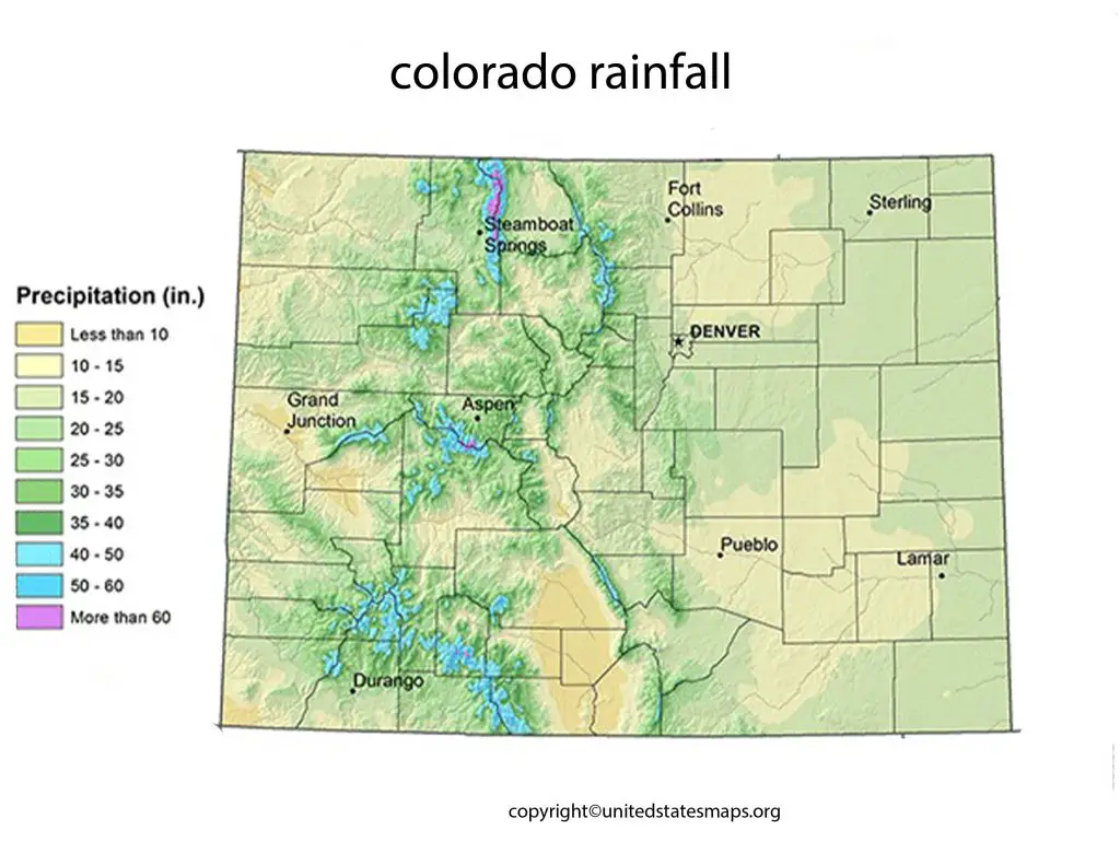
Rainfall Map of Colorado
The Colorado average rainfall map provides a visual representation of the average amount of precipitation that falls in different parts of the state. The data used to create the map comes from various sources, including weather stations, radar technology, and satellite imagery.
The rainfall map of Colorado is a crucial tool for understanding the precipitation patterns in the state. The map illustrates the amount of rainfall that falls in different parts of Colorado throughout the year. The data used to create the map comes from various sources, including weather stations, radar technology, and satellite imagery.
The rainfall in Colorado varies significantly depending on the location and elevation. The western part of the state, which is mountainous, receives much more precipitation than the eastern part, with an average annual rainfall of around 50 inches. Additionally, the timing and intensity of precipitation also vary across the state, with some regions experiencing heavy rain or snowfall during specific seasons.
The rainfall map of Colorado provides a visual representation of the precipitation patterns in the state, making it easier to understand the variations in rainfall across different regions. This information is useful for farmers, water resource managers, and policymakers, who can use it to make informed decisions about irrigation, drought management, and water conservation efforts. Additionally, the map can help residents and visitors to Colorado plan outdoor activities and prepare for weather events.
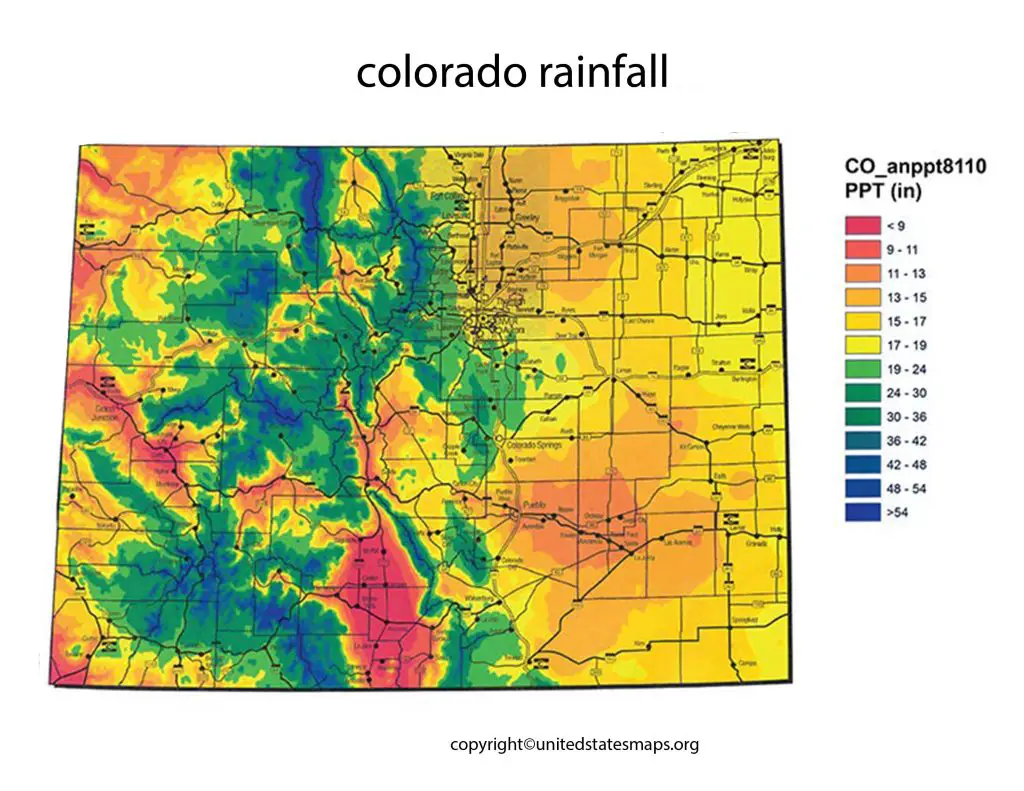
Colorado Annual Rainfall Map
The average rainfall map of Colorado is a useful tool for understanding the precipitation patterns across the state. The map represents the average amount of precipitation that falls in different parts of Colorado annually. The data used to create the map comes from various sources, including weather stations, radar technology, and satellite imagery.
The Colorado annual rainfall map is a valuable tool for understanding the precipitation patterns in the state over the course of a year. The map represents the average amount of rainfall that falls in different parts of Colorado annually. The data used to create the map comes from various sources, including weather stations, radar technology, and satellite imagery.
The annual rainfall in Colorado varies significantly depending on the location and elevation. The western part of the state, which is mountainous, receives much more precipitation than the eastern part. With an average annual rainfall of around 50 inches. In contrast, the eastern part of Colorado tends to be drier. With an average annual rainfall of around 15 inches. Additionally, the timing and intensity of precipitation also vary across the state. With some regions experiencing heavy rain or snowfall during specific seasons.
The Colorado annual rainfall map provides a comprehensive overview of the precipitation patterns in the state. This information is useful for farmers, water resource managers, and policymakers. Who can use it to make informed decisions about irrigation, drought management, and water conservation efforts. Additionally, the map can help residents and visitors to Colorado plan outdoor activities and prepare for weather events.