Discover the Land of Lincoln like never before with our comprehensive Illinois county map featuring all 102 counties and their cities. Whether you’re a resident or a visitor, our map will help you navigate the state’s major highways, explore hidden gems, and plan your next adventure.
Check out our other County Maps:
- Connecticut County Map
- Delaware County Map
- Florida County Map
- Georgia County Map
- Hawaii County Map
- Idaho County Map
Illinois County Map
Illinois is a state in the Central Midwestern region of the United States of America. Known for its diverse cultures and vibrant cities, Illinois is divided into 102 parts, each with its own history and uniqueness. If you’re planning a trip, it is a good idea to familiarize yourself with the map of that state, which covers each of the 102 parts. Below are 3 types of maps that can assist you while attending Illinois.
The Illinois county map includes major cities such as Chicago, Springfield, Peoria, and Rockford. Each city has its unique charm and history that is worth exploring. The map also includes important landmarks like Lake Michigan, Starved Rock State Park, Shawnee National Forest, and Lincoln’s Tomb. With an Illinois counties map in hand, you can plan your trip to ensure that you don’t miss any must-see locations.
Furthermore, an Illinois counties map helps you understand more about each county’s demographics and economy.
A Map of Illinois Counties is similar to a county map, but it also includes information about major cities and landmarks in the state. This type of map is useful for people who want to plan a more detailed trip and who want to see all the major attractions in each county.
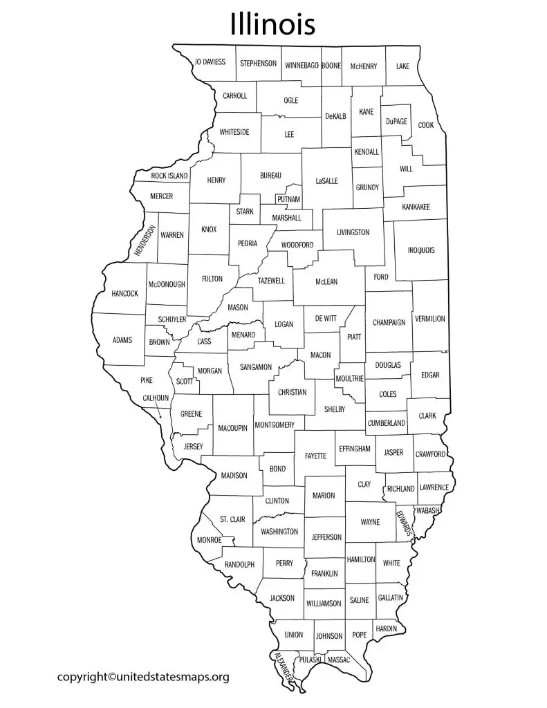
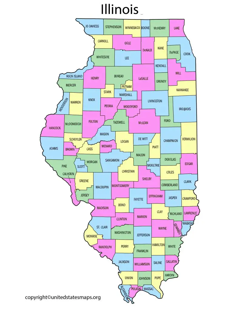
An Illinois County Map shows the boundaries of each county in the state. This map is helpful if you’re trying to get a sense of the overall layout of the state and the location of each county. You can use this map to plan a road trip or to get a general idea of where you’ll be traveling.
Illinois Map with Counties
An Illinois Map by County is a map that shows each county in the state along with information about the major cities and landmarks in that county. This type of map is useful for people who want to explore specific regions of the state or who want to learn more about the history and culture of a particular area.
The American Midwestern area includes the state of Illinois. Some of the biggest cities in the nation, like as Chicago, Springfield, and Peoria, are located there. It can be difficult for both visitors and people to get around in its many regions because of the over 102 counties that are dispersed over its huge landscape. Fortunately, an Illinois county map is accessible to help individuals locate themselves and get where they need to go fast.
The Illinois map with counties has become an essential tool for individuals who want to explore this great state. It features detailed information about each county’s location, population size, and major attractions. Additionally, it highlights famous landmarks such as Lake Michigan and Abraham Lincoln’s birthplace in Springfield. The map also comes with useful labels that provide insight into each county’s history and culture.
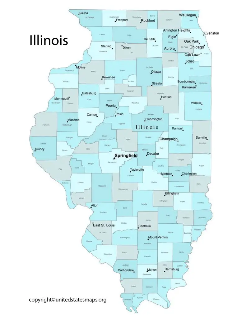
An Illinois Map with Counties is similar to a county map, but it also shows major cities, highways, and bodies of water. This type of map is helpful if you’re planning a more detailed trip and want to see the major landmarks and attractions in each county.
County Map of Illinois
An Illinois Counties Map is a map that highlights each of the 102 counties in the state. This type of map is useful for people who want to learn more about the history and culture of each county or for those who want to explore specific regions of the state.
Illinois is a state located in the midwestern region of the United States. It is known for its diverse economy, including agriculture, manufacturing, and technology. The state is also home to many cities and counties that offer unique attractions and opportunities for residents and visitors alike.
One of the best ways to explore Illinois is through its city county map. This map provides an overview of all the cities and counties in Illinois, making it easy to plan your travels or even decide where to live. With over 1,200 municipalities throughout the state, there are plenty of options to choose from.
The Illinois city county map also highlights some of the top tourist destinations in each area. From Chicago’s world-famous museums and architecture to Springfield’s Abraham Lincoln Presidential Library and Museum, there are plenty of things to see and do throughout Illinois.
An Illinois City County Map is a map that shows the location of each city in the state along with the county in which it’s located. This type of map is useful for people who want to explore specific cities or for those who want to learn more about the different regions of the state.
A County Map of Illinois is a detailed map that shows the location of each county, as well as major highways and landmarks. This map is useful for planning a road trip or for exploring a particular area of the state.