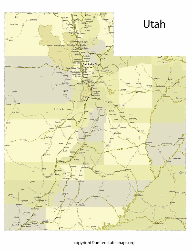
Discover the unique landscape of the Beehive State with our detailed Utah County Map. From the towering peaks of the Wasatch Mountains to the stunning rock formations of Arches National Park, Utah is a state full of natural wonders. With our interactive map, you can explore the cities and towns of each county and plan your next Utah adventure.
Utah County Map
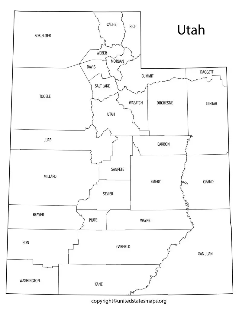
The Map of Counties in Utah provides a clear and accurate representation of the state’s counties, highlighting each county’s boundaries and notable features. This map is useful for anyone who wants to explore the state’s diverse landscapes, plan a trip, or conduct research on the state’s geography and history.
Utah is a land of rugged beauty, with stunning vistas and unique natural wonders. Home to five national parks, the state is a mecca for outdoor enthusiasts looking to hike, climb, ski or simply enjoy the breathtaking scenery. And while many visitors flock to popular destinations like Zion National Park or Bryce Canyon, there’s much more to explore beyond these well-known landmarks. Check other Utah maps:- Utah Rainfall Map, Blank Utah Map, Labeled Utah Map.
A Utah county map can an invaluable tool for discovering the state’s hidden gems. From the towering peaks of the Wasatch Range in Salt Lake County to the colorful sandstone formations of San Juan County in the southeast, each region has its own unique attractions waiting to discovered. With over 29 counties spanning across 84,899 square miles, Utah offers an abundance of destinations for those willing to venture off-the-beaten-path.
Utah County Map is a visual representation of the counties in the state of Utah, USA. It provides a detailed layout of the state’s counties, including their names, boundaries, and geographical features. The map is widely used by travelers, students, and researchers for various purposes such as planning a trip, studying the state’s geography, or conducting research.
Utah Map by County
The Counties in Utah Map is a comprehensive guide to the state’s counties, providing a detailed layout of each county’s boundaries and geographic features. This map is an excellent resource for travelers, students, and researchers who want to learn more about the state’s diverse geography and history, as well as for those who want to explore the state’s unique landscapes.
Utah is a state located in the western region of the United States. It is known for its vast and varied landscapes, ranging from snow-capped mountains to desert valleys. If you’re planning on traveling to Utah or simply interested in exploring the state, it’s important to have an understanding of its counties and their locations.
A Utah map by county can a valuable tool for visitors and residents alike. With 29 counties in total, each with their own unique features and attractions, a county map can help guide your travels and ensure that you don’t miss out on any hidden gems along the way. Some of the most popular counties include Salt Lake County, which is home to Salt Lake City and numerous ski resorts; Summit County, which boasts Park City’s famous ski slopes; and Washington County, which offers stunning red rock formations in places like Zion National Park.
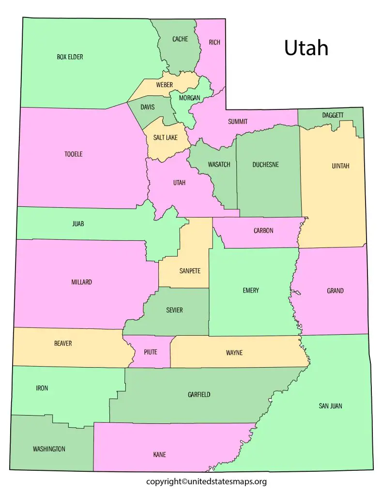
Utah Map by County is an informative map that outlines the state’s counties with detailed information about their locations and boundaries. This map is useful for understanding the state’s geography and demographics, as well as for identifying the various regions and cities within the state. The map provides an easy-to-read layout that makes it easy to identify each county and its surrounding areas.
Map of Utah Counties
The County Map of Utah is an essential tool for anyone who wants to explore the state’s diverse geography and unique landscapes. This map outlines each county’s boundaries and highlights its notable features, including cities, parks, and landmarks. The map is useful for planning trips, studying geography, or conducting research on the state’s various regions.
The Map of Utah Counties is an accurate and informative representation of the state’s counties, providing detailed information about each county’s location, boundaries, and notable features. This map is useful for students, researchers, and travelers who want to learn more about the state’s geography and history, as well as for those who want to explore the state’s diverse landscapes.
The Utah County Map with Cities is an essential tool for anyone who wants to explore the state’s diverse cities and landscapes. This map outlines each county’s boundaries and highlights its notable cities, parks, and landmarks. The map is useful for planning trips, studying geography, or conducting research on the state’s various regions and urban areas. With this map, visitors can easily navigate the state’s cities and explore its unique landscapes, from the mountains to the deserts and beyond.