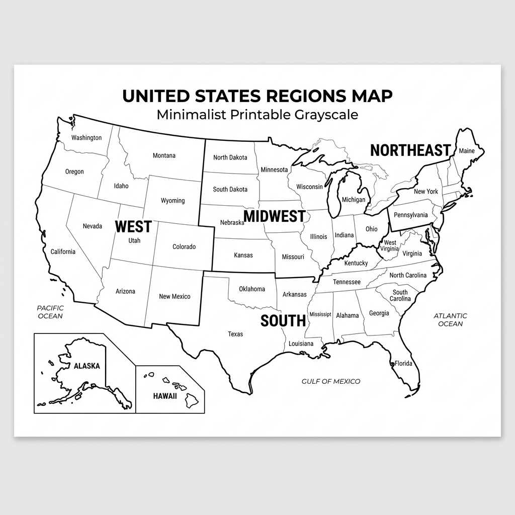
A US Regions Map is a map that shows the regions of the United States. The country is traditionally divided into four regions: Northeast, Midwest, South, and West. Geography education, demographic studies, travel planning, and regional analysis are all areas of application of these regions. Regional maps can help you identify the states and understand regional boundaries throughout the United States, whether you are looking for a printable US regions map, a US regions map with state names, or a blank US regions map for classroom learning.
Printable US Regions Map
A Printable US Regions Map for students, teachers, homeschoolers, and those studying American geography. Printable maps offer a precise visual map of the country’s areas and are suitable for educational projects, worksheets, presentations, and reference.
The US regions map PDF is preferred by many users as it can be downloaded, printed, and used offline. Often used in geography courses, regional studies, and class projects.
What Are the 4 Regions of the United States?
The United States is generally divided into four primary regions, each with its own geographic characteristics and group of states.
Northeast Region
The Northeast is located along the Atlantic Coast and is known for its historic cities, cultural landmarks, and educational institutions.
Midwest Region
The Midwest is often called America’s Heartland and is recognized for its agriculture, manufacturing industries, and Great Lakes region.
South Region
The South is the most populous region in the country and is known for its diverse culture, warm climate, and rapidly growing metropolitan areas.
West Region
The West contains some of the nation’s most diverse landscapes, including mountains, deserts, coastlines, forests, and national parks.
A United States regions map helps users quickly visualize these regional divisions and understand how states are grouped across the country.

US Regions and States
The following table shows the states included in each region.
| Region | States |
|---|---|
| Northeast | Maine, New Hampshire, Vermont, Massachusetts, Rhode Island, Connecticut, New York, New Jersey, Pennsylvania |
| Midwest | Ohio, Michigan, Indiana, Illinois, Wisconsin, Minnesota, Iowa, Missouri, Kansas, Nebraska, North Dakota, South Dakota |
| South | Texas, Florida, Georgia, Alabama, Mississippi, Louisiana, Arkansas, Tennessee, Kentucky, Virginia, West Virginia, North Carolina, South Carolina, Maryland, Delaware, Oklahoma |
| West | California, Oregon, Washington, Nevada, Idaho, Montana, Wyoming, Colorado, Utah, Arizona, New Mexico, Alaska, Hawaii |
This US regions and states map is useful for identifying which states belong to each geographic region of the United States.
US Regions Map with State Names
A US Regions Map with State Names makes it easier to identify regional boundaries while also locating individual states. These maps are commonly used in schools, geography courses, and educational projects because they provide a clear visual reference for understanding the country’s regional organization.
Students often use a labeled US regions map to learn state locations, practice map-reading skills, and prepare for geography quizzes.
Labeled US Regions Map
A labeled US Regions Map clearly displays the names of each region along with state boundaries. This type of map is particularly helpful for students, teachers, and researchers who need a quick reference guide to the regions of the United States.
Labeled maps are commonly used in classrooms because they help learners distinguish between the Northeast, Midwest, South, and West regions while improving their understanding of American geography.
Blank US Regions Map
A Blank US Regions Map is designed for learning and practice. Unlike a labeled map, a blank version allows users to identify and label regions independently.
Teachers frequently use blank maps for:
- Geography worksheets
- Classroom activities
- State identification exercises
- Regional studies
- Educational assessments
A blank regions map of the United States is an excellent tool for reinforcing geography skills and testing regional knowledge.
5 Regions of the United States

While the four-region model is the most common, some educational resources divide the country into five regions.
The 5 Regions of the United States include:
- Northeast
- Midwest
- South
- Southwest
- West
In this model, states such as Arizona, New Mexico, Texas, and Oklahoma are often grouped within the Southwest region. A 5-region map of the United States provides a more detailed view of the country’s geographic divisions and is commonly used in school curricula.
US Regions Map for Kids
A US Regions Map for Kids helps young learners understand geography through simple and easy-to-read maps. These maps often feature clear labels, colorful regional boundaries, and student-friendly layouts that make learning more engaging.
Teachers and parents use regional maps to introduce children to state locations, regional groupings, and basic geography concepts. A kid-friendly United States regions map can make learning about the country both educational and enjoyable.
Why Use a US Regions Map?
A Regional Map of the United States serves many educational and practical purposes. It helps users understand how states are grouped geographically while providing a simple way to study American geography.
Common uses include:
- Geography education
- Classroom instruction
- Homeschool lessons
- Regional studies
- State identification practice
- Educational worksheets
- Travel planning
- Research and reference
Whether you are a student, teacher, or traveler, a US geography regions map provides a useful overview of the country’s major regions.
Frequently Asked Questions
How many regions are in the United States?
The United States is commonly divided into four major regions: the Northeast, the Midwest, the South, and the West.
What are the 5 regions of the United States?
The five-region model includes the Northeast, Midwest, South, Southwest, and West.
What region is Texas in?
Texas is generally considered part of the South, although some educational maps classify it within the Southwest region.
What region is California in?
California is located in the Western region of the United States.
What is a Printable US Regions Map?
A Printable US Regions Map is a downloadable map that can be printed and used for educational, reference, and classroom purposes.
What is a Blank US Regions Map?
A Blank US Regions Map is an unlabeled map used for geography exercises, worksheets, and regional identification practice.
Why do schools use US Regions Maps?
Schools use US Regions Maps to teach geography, regional boundaries, state locations, and map-reading skills.
What is the difference between a labeled and blank US Regions Map?
A Labeled US Regions Map includes region names and state information, while a Blank US Regions Map allows students to label the regions themselves for educational practice.
Thanks this was very very useful and well thought out…